A tribute to the generosity and patience of our many landowners and the dedication of our volunteers.
The following story by Terry provides his perspective on the Avon Trail as a hiker, member and volunteer over the past 10 years.
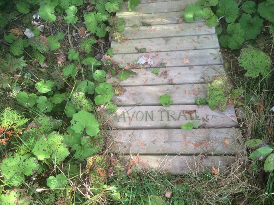
INTRODUCTION
This is an account of my involvement with this relatively unknown gem in Southwest Ontario.
Upon returning to Canada in early 1984, I decided to be involved with the Avon Trail and become a member. Every month, a faithful volunteer would drop off a newsletter. I obtained the trail map guide and, from time to time, would venture forth with members of my family and our friends. Hiking regularly is immensely beneficial for anyone, but especially for older folk, and some people find being in nature is a suitable location for meditation, which clears the mind of unhelpful thoughts and worries.
On one social occasion around Wildwood, I met the original visionary creator of the trail, Dr Crosby Kirkpatrick. He was then in his 90’s. He had been a family physician in New Hamburg. Only later, when I got intimately involved with the landowners of the trail, did I begin to appreciate what a tremendous undertaking it must have been to approach many landowners to obtain access to their land and create more off-road sections of the trail.
TRAIL ETIQUETTE
It should be stated right at the outset that the continuing existence of the trail is hugely dependent on the goodwill of our approximately 100 landowners, who are protected from liability by the Occupiers’ Liability Act. This means that they cannot be sued for misadventure incurred by hikers, provided no dangerous hazards are present. Users of the trail must observe trail etiquette, which includes staying on the trail, taking nothing but photographs, keeping your dog on a leash, not walking on crops and not stopping for picnics or camping. Littering is also a no-no. We have permission from the owners for hiking and snowshoeing only.
HIKING THE TRAIL IN ALL SEASONS
It is recommended that users of the trail refer to the ONDAGO app for up-to-date information about the status of the trail. There are parts of the trail that are signposted indicating restricted use during the deer hunting season from September to December. The Avon trail website also sets out deer hunting restrictions late in the year. Though the trail is not “accessible,” the varying terrain is not particularly challenging for folk of average fitness. Good footwear is essential.
The transformation on the trail in spring is truly awesome. Plants appear that have been dormant in the winter. I had never seen Dutchman’s breeches before. Fields become covered in trilliums in May. Jack-in-the-pulpits abound, as does skunk cabbage. Hepatica, Solomon’s seal, sarsaparilla and trout lilies, blue cohosh and Queen Anne’s lace appear. Patches of remnant tiger lily gardens can be seen here and there. Ferns reappear after the snow melts. Lichens of various shapes and sizes are present all year round. Yellow lichens are poisonous. In the fall, we find eminently edible puff balls. We find many other varieties of fungi along the trail. In the summer, wild raspberries and apples grow in profusion. Despite receiving no apparent care, they are often laden with fruit.
Birds such as Baltimore orioles and Indigo buntings that have been south in the winter arrive. Some are transient and are passing through to the north. One spring day, two of us spotted a pair of Eastern bluebirds, which many hikers have never seen. There are now places near the trail where nests of bald eagles can be seen. Wild turkeys are often encountered, particularly on the route to hiking locations. One of our members photographed a nest containing wild turkey eggs, and I once saw a grouse. Other birds heard, if not seen, include grosbeaks, red-tailed blackbirds, warblers and woodpeckers.
One day in Oxford County, someone turned over a log and spied a salamander. We have had brief encounters with a fox, raccoons, and groundhogs and, on one occasion, a pig which turned out to be a tame domestic escapee. Deer are frequently encountered. Several years ago, a landowner photographed a cougar near the trail in broad daylight. Though they are around, we rarely see possums, skunks or coyotes, and the only snakes seen are harmless garter snakes.
Spring and summer hiking have their challenges. Adequate water and applying sunscreen are advised. In spring, the mosquitoes are so bad that one hiker who regularly visits Costa Rica declared that they are not as bad down there. Insect repellent and/or bug jackets are necessary. To the best of my knowledge, we have not yet encountered ticks, which are most active in spring and fall. We cryptically advise newcomers to check themselves for “moles with legs” when they shower after a hike. If you discover one, you should use fine-tipped tweezers and wear gloves, making sure you gently pull it straight out. Shorts and short sleeves do not cut it for the above reasons, and because there is poison ivy and stinging nettles in places alongside the trail. Poison ivy is regarded as a noxious weed and should be destroyed wherever it is found. If you do come in contact with it directly or from clothing, you should wash your skin and clothing with strong soap. Giant hogweed and cow parsnip, which are poisonous to touch, are present at locations beside parts of the trail.
Snowshoeing and cross-country skiing on parts of the trail is pleasurable when there is enough snow on the ground to make it worthwhile.
ORGANISED HIKES and SOCIAL EVENTS
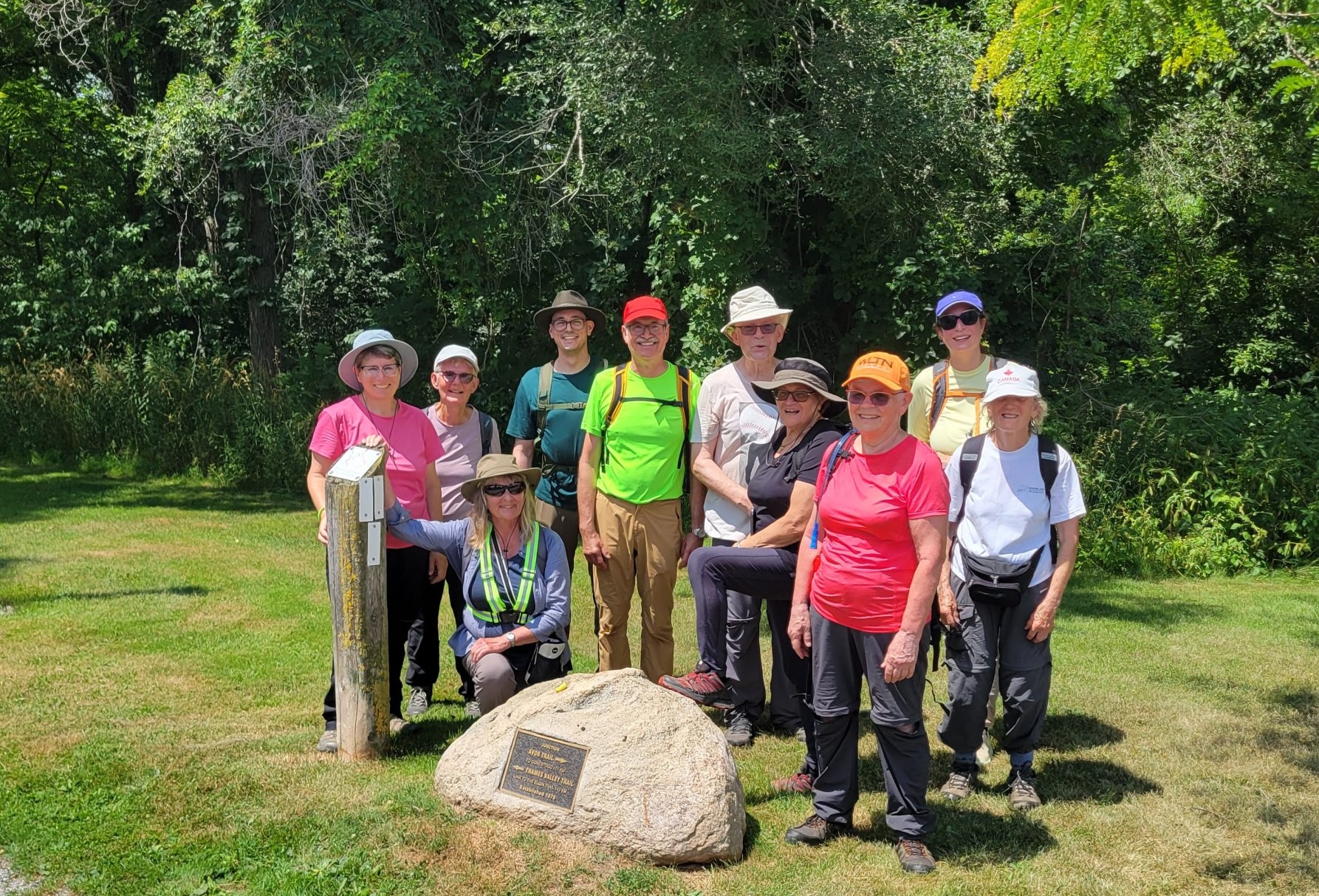
About 10 years ago, we began having a casual hike on Tuesday mornings, appropriately labelled a ramble. We still gather at the parking lot of the Allman Arena on Morenz Drive at 8.45 am. Every participant signs a waiver once a year. The rambles are led by certified hike leaders who have completed a weekend of extensive instruction in London, Ontario. The leader chooses a route which he/she has reconnoitred beforehand, then we carpool and set out for the chosen starting point. It can take between 10 to 40 minutes to get there. Latterly, the leadership of the hike has varied from week to week. These rambles are a good introduction to the trail and its users and are followed by coffee (optional).
Longer hikes, which I have not been involved with, are often arranged on weekends. About every five years, we have an end-to-end hike over several days or several weeks, and those who complete it can purchase an end-to-end badge. Each October, we have a 22 km hike around Wildwood Lake called the Wildwood Challenge. Instituted in 2018 by then President, Bernard Goward, it is now so popular that there is a waiting list for many hopeful registrants. Hikers from other parts of Ontario participate each year.
The Avon Trail and some members host social events. There is usually a “Show and Tell” night in February where members do various presentations – often on trips they have been on. We have in the past had barbecues on members’ farms and a potluck lunch at a member’s cottage in Goderich. Each year, there is a lunch for volunteers. In November, the AGM is well-attended and good speakers have been appreciated.
TRAIL MAINTENANCE
Around 2015, I started to get involved with the most essential activity of the trail, namely, trail maintenance. The public has a very minimal concept of the many hours of volunteer work involved in this activity at all times of the year, but especially in the summer, when weather conditions result in almost tropical growth of the grass. We need to ensure that the trail is still passable. This is why, when choosing a new route, paths through the bush are infinitely preferable to the edges of fields. The initial work in making a trail through the bush can be daunting, but the maintenance is far less. Also, users of trails on the edge of fields can easily step on crops. The more use a trail receives, the less the need for keeping the grass cut. We have no control over ATV and cycle use on the trail, but they can inflict damage, especially when it is wet in the spring. Logging is also sometimes carried out and requires remedial work thereafter. Almost everywhere we work is on private land.
Things are relatively quiescent over the winter when grass is not growing, and it is too cold to paint blazes to mark the trail. (The temperature must be 15 °C for paint to dry.) Winter storms often result in trees coming down in forested sections, so activity in the spring involves clearing such sections. Using an auger to dig holes for posts is also hard work, though we have used groundhog holes. The ground around here is never really frozen till January, so holes can be dug till then. Latterly, pounding holes into the ground has become the preferred method for the location of posts.
Some parts of the trail are quite swampy. Two of us were working on a new part of the trail just south of Harmony when my companion got stuck in the mud and had to be assisted to free himself. A team of us were cutting through a grove of trees to bypass a field edge. Often, volunteers brought their equipment, and one chap’s chainsaw gave up the ghost. Returning to his car, he tried to take a shortcut and fell flat on his face in a drain, all of which points out one of the cardinal rules of trail maintenance – never go alone. Chainsaw operators are expected to undergo a chainsaw certification course.
Trail maintenance or even hiking itself can result in overheating in the summer. You get so drenched with sweat and suffer if you do not carry extra water. Another volunteer and I were clearing weeds along the edge of an electric fence when I accidentally touched the live wire. The shock resulted in me throwing the implement I was holding into a field occupied by some retired RCMP horses, who bolted after they were startled by this sudden motion. (Electric shocks from fences do not have enough voltage to cause any lasting damage.) Another time, two of us were trying to chart a route across a swamp on the Forest Road property from which we have now been excluded due to a change of ownership. In this area, there were supposed to be 8-foot sink-holes, so we were proceeding cautiously. We were almost back on solid ground when we encountered a deeper stream that flowed over the top of our Wellington boots.
Another hazard of trail maintenance is clearing thorn bushes. I often wondered what their purpose is in the scheme of things, but have learned from an expert that they serve several purposes.
- The buckthorn bushes improve the soil where they grow and provide shelter for new plants.
- Their berries have medicinal value.
- Some birds use their thorns to impale smaller birds they have captured. If you get pricked when trimming them, the site of injury develops a purulent sore, which is surprising because the thorns look clean and sterile. However, this does not happen in the winter when the thorns do not elicit such a reaction.
MONITORS
At this juncture, it is worth mentioning something about monitors. These are volunteers who are assigned part of the trail to keep in good shape. Usually, two are assigned to each section. Their job is to keep the grass cut, trim off branches, freshen blazes and call in the chainsaw crew to cut through fallen logs when necessary. The Avon Trail is deeply indebted to these trail warriors. More volunteers are always welcome.
An explanatory comment about blazes would be helpful. There are two types of blazes used on the trail. White vertical blazes are painted using a 2” by 6” inch vertical template to mark the main trail. Direction changes are marked by an additional blaze above and to the right or left of the lower blaze, depending on the direction intended, and they have to be painted from each end of the section. Identically sized blue blazes mark side trails. In some places, you see nailed-on plastic or metal blazes, but they are usually reserved for inert objects like fence posts or lampposts. Both the landowners and we are anxious that blazes are not nailed to live trees. Painting blazes on live trees is the preferred option.
LANDOWNER CONTACT
Toward the end of 2015, I was asked if I would be willing to take over the role of Landowner Relations. Ideally, the 130km trail should flow uninterruptedly from one end to the other on off-road routes. We are and always will be deeply indebted to landowners who permit us to traverse their properties. Because not every landowner is agreeable for a variety of reasons, we must connect off-road routes by using the road. Like everyone else, I was keen to secure more off-road routes, so I accepted the challenge.
I should mention that it is not always easy to find out who the landowner of a certain property is because of privacy issues. My policy was always to speak directly to the landowner to obtain permission to traverse their property. Phoning was a challenge because many people now have cell phones. If the landowner has concerns, they are informed that they are protected under the Occupiers’ Liability Act. The long-term survival of the trail is greatly enhanced when potential landowners walk the proposed route with you. I emphasize the positive aspects of having a trail on their property. From a conservation point of view, we can share the stewardship of the land with the landowners. We can also be the eyes and ears for them for what is happening on the trail. For example, we might spot evidence of a grow-op and more recently, with the epidemic of homelessness, we can advise the landowners about encampments we notice, as part of our unwritten contract with them. It is their responsibility to eject trespassers, not ours. We have found it best to just have a handshake arrangement with our landowners. This simplifies their sale when they want to sell, but it does mean we can lose access at any time, and we then need to get permission from new landowners.
CREATION OF NEW ROUTES
It should be noted that after a rough idea of where a new trail should go is conceived based on Google Maps and input from landowners, two or more of us then go over the proposed route and modify it as we go along. I have been helped in this way numerous times by Bruce Graham, currently the Avon Trail Board President. Two heads are always better than one. We have had two volunteer couples from Waterloo who have been immeasurably helpful over the years. One couple, Jamie and Jan Hember, have tirelessly helped map new trails everywhere from St Marys on, and especially latterly in Waterloo. Dick and the late Jane Pullin, the other couple, were monitors of the Schneider-Musselman area for years.
Having ascertained where the new route is going, we then assemble a team to begin the physical work. This may just involve cutting branches with loppers, but often chainsaw work is required if trees need to be cut down. In muddy places, skids may be necessary.
Stiles are a necessary feature of many parts of the trail. A lot of thought has gone into their design. Under the instigation of long-term volunteer Dennis Rawe, they have been considerably modified. In earlier times, hikers tended to slip sideways as the stiles were more like ladders with rungs rather than steps being used. Climbing stiles for older folks was challenging. The new steps were fixed into grooves on the sides of the stile, providing greater stability. A platform was added at the top so that users could turn around to go backwards down the stile. When walking with hiking poles, they should be thrown over ahead of you as it is dangerous to cross stiles with these still in hand. Dennis has also been involved in the design and construction of many of the bridges built on the trail.
HIGHLIGHTS ON THE TRAIL FROM END TO END
St Marys to Wildwood Conservation Area
The Avon Trail starts behind the quarry and tennis courts next to the Thames River at a point where the Thames Valley Trail ends. We had a plaque there, but it had been ripped off. Enquiry led me to a company in London who came up with a trailer one weekday morning and spent the morning drilling out a piece from the rock so that the new plaque, which had been made at a foundry in Baden, could be set into the depression so created. It was then glued and held in place with screws. Several years later, it has survived unscathed from the attention of vandals. The first 5 or so km of the trail is largely through the town of St Marys. Back in the 80’s a councillor complained that our blazes constituted graffiti, and they had to be removed. This led to complaints from American hikers who couldn’t find their way through St Marys. Fortunately, the parks supervisor for St Marys was sympathetic to our need to restore the blazes. He drove us over the route, and soon afterwards we had the blazes replaced. A park at the north end of the town, just below the old railway track, is the home of a maple tree planted in memory of one of our trail maintenance crew, Ken Ferguson. It is thriving.
At the north end of St Marys we used to go straight east along Line 14. I thought I would try to get more off-road routes here and approached a farmer in the vicinity. He directed me to a landowner further back. He and his wife proved to be fully in support of the idea and suggested that it was better than I had envisaged. After getting permission from neighbours to the south and east of him, we walked the chosen route with him and the wife of the landowner to the east, discovering in the process a lighthouse that had been built by an adjacent landowner for his son. It featured in our 2020 calendar but is often obscured when the corn grows high. This route took us north of where were planning to go, and it was suggested that we check out a return route parallel to Road 122 but it was a busy time for the landowner so we had to be satisfied with returning on Road 122 to connect with the existing trail east of Road 122 which leads overland past McCully’s farm to the Wildwood Campground.
Just south of McCully’s farm is a tree planted in memory of Tom Miller, an enthusiastic supporter of trails. Just before we reach the Wildwood Campground, we pass a sulphur spring next to the river below the dam. The route around Wildwood Lake is the one section of the trail where we have a written contract with the landowner, the Upper Thames Conservation Authority. We used to hike south of the lake, and the trail remains there, but our route is now north of the lake. We pass through Wildwood Campground without charge.
We share this part of the trail with cyclists. More recently, the Upper Thames Conservation Authority has permitted us to have supplementary Avon Trail notices beneath the Wildwood signs. Somewhere along the trail is a tree which has partially grown around an Avon Trail sign.
Wildwood to Harmony
Not a lot has changed on the section of the trail running eastward from the east end of Wildwood to Line 33 along Trout Creek, which empties into Wildwood Lake. Parts of it are closed each December for hunting. About 1km before the trail emerges onto Line 33, the landowner has persistently left a gap between planted corn so that hikers are not impeded when crossing this 25m stretch.
The next section up, Line 33 and across to Perth-Oxford Line, has undergone lots of heartbreaking changes in the last 10 years, largely not of our making. In previous times, we only walked a short distance up Line 33 before turning right at the Rod and Gun Club to go overland to Perth-Oxford Line. Later, we left the road further north, but this whole section was closed in 2020 during Covid when the area was invaded by many who did not follow trail etiquette. The whole route was very beautiful and popular, crossing over Trout Creek on rocks at one point. It is replete with trilliums in the spring.
Not all was lost, however. The midsection was purchased by a new landowner empathetic to conservation issues, so we have now constructed a new trail there, which was dubbed the Elizabeth Loop after our late Queen, which enables us to reuse the trillium section. So far, permission to access it from the west, from line 33, has not been obtained. It emerges on Line 35. We do have permission to go east from Line 33 to Line 35, the Embro Road.
Previously, we used to go overland from Perth-Oxford Line to Camp Bimini on the Embro Road. All of this had been closed except the northern end, which was dubbed the Bimini Loop. This was very popular before it too was closed in 2021.
Also in 2021, the midsection of the trail from Camp Bimini to north of Harmony was closed. We were able to improve the first part of this route, creating the Periwinkle Loop and at the Harmony end, a friendly landowner allowed us to loop back to Road 112. Part of the Periwinkle Loop went up through the first experimental woodlot planted in 1905. It has become the birthplace of reforestation in Ontario. At the Harmony Loop end, it is very swampy but was replete with butterflies when we built it during an admittedly warm March.
The problem that resulted in the closure of these two sections was caused by parked vehicles impeding the passage of large farm machinery, which the narrow roads in the area could not accommodate. In September 2021, a friendly landowner made the constructive suggestion of building a parking area on Line 20 where hikers could park 5 cars. Across the road from Camp Bimini is a small loop which can be traversed in about 5 minutes, which is a welcome respite after coming down the Embro Road from Perth-Oxford Line. In 2024, we were able to obtain permission to bypass the closed mid-section connecting the Periwinkle and Harmony Loops, thus reopening the entire section from Line 20 south of Camp Bimini to just north of Harmony on Road 112. The parking area just north of the entry point is proving very beneficial.
Harmony to Perth Line 40
When we emerged from the Harmony Loop section, we walked north on Road 112 and through Harmony to a long-horned cattle farm whose perimeter we skirted before merging on Line 26. We then proceeded east along the road to a farm just beyond Road 111, where we turned north to go overland. It seemed like a lot of road walking. Could a more off-road route be found? The ideal solution seemed to be to use the Harmony Conservation Area to walk through to Road 111, but permission was not granted for the last critical 100m section at the eastern end.
The other solution was to go straight east from Road 112 to Road 111. The first part was so swampy that we had to use pallets to traverse it. The second half, through a grove between two farms, was straightforward, and there is probably what is a 100-year-old shagbark hickory tree in this section.
After coming out on Road 111 the plan was to proceed north along Road 111 to Line 26, but we were able to obtain permission to traverse the rear of the corner property to reach Line 26 opposite where the trail continues north. Initially, we follow a stream, then go straight north through the bush to Line 26. We spent 4 days cutting a path through these trees.
The trail goes overland north from Line 26 to Pork Road. Early on, we pass a very vigorous maple tree planted to mark Canada’s sesquicentennial in 2017. The northerly end of this section has recently been revised and now comes out on Road 110. Here we turn left to go north to Highway 7 and 8, then proceed west via Forest Road to Road 111. We have a section of trail that runs north for several hundred metres from Forest Road to Hwy 7 and 8, but it remains in isolation. We now must continue north on Road 111, before heading east at the Avon River to join up with the sections that have been reopened through to Road 110.
The Side Trail
This starts at the Avon River on Road 111 and proceeds west through Stratford, winding up in the T.J. Dolan Area. Permission has recently been obtained to paint blue side trail blazes along this route. The eastern end of this side trail, being close to town, has been the site of repeated encampments by homeless folk. Strangely, when these folk depart, they often leave behind huge piles of still usable material which has to be gathered up and taken to the dump. People also dump trash at entry points.
Road 110 to Perth Line 40
Happily, all overland routes immediately east of Road 110 have not changed much. A couple of us cut a trail through a grove of pines along the side of Line 43 near the farm shop. My companion dubbed this alteration “Lovers’ Lane,” which proved to be the first of several such constructs. Beyond the farm shop, there is a trail section that many hours were spent creating a boardwalk over a swampy sound. It is 244m in extent, and pressure-treated timber has been used. Its presence protects the underlying fragile wetland. Just beyond the boardwalk is a marker indicating the midpoint of the trail, but the trail has changed so much that it is now redundant.
A little further along to the side of the trail, there are the remains of a boys’ club house. Only the chimney remains, but it is an interesting spot for photo shoots and is featured in the 2020 calendar. Near the site of the disintegrating chimney, the conditions became so muddy that the trail had to be rerouted through the bush in 2024.
Perth Line 40 to Nith River
We cross a little-used route immediately south of Amulree. We used to head east along Erb Road, then cross through the bush to Road 106. This last overland route was closed several years ago, forcing us to go along Erb Road to Road 106 on Mennonite Corner, then north up Road 106 to connect with the ongoing trail there. I wondered whether it might be possible to head west-east from Road 107 north of Amulree, heading straight across to Road 106 parallel to Erb Road. 5 landowners were involved, so it took a while. We now head up Road 107 from Amulree to connect with this exquisite cross-country route, which we share in the winter with snowmobilers. The rule is that we step off the trail when a snowmobile comes along. This route was planned with the help of the wife of a former director. She is very concerned about the prevalence of garlic mustard, an edible imported herb. It is one of Canada’s most aggressive forest invaders, threatening biodiversity, especially maples.
North of Carmel-Koch Road on Wilmot-Easthope Road, the trail went overland to Nafziger Road. This section was closed by two landowners over concerns about their horses being touched in the first instance, and because of alleged trash in the second. I wondered how we could circumvent this closed-off section. This was my first attempt at rerouting the trail in my role as Landowner Relations. I approached the lady landowner south of Carmel-Koch Road, and she walked with us along the proposed new route that entered her property off Wilmot-Easthope Road. She kindly permitted us to do this, but we needed to use the driveway that went north. However, there was an issue with this because the driveway was on another landowner’s property. This person allowed the lady landowner and her guests to use the driveway, but not hikers. We therefore had to go a little further east onto the neighbouring property, where we had to traverse a ditch. The landowner kindly built a bridge for us to use.
We created a new trail initially through a bush section going north from Carmel-Koch beside the Krempien Drain. After emerging from this short bush section, we head north along the edge of a field beside the Krempien Drain, which must be crossed to proceed east to Nafziger Road. The bridge crossing this drain was located further north on property we could no longer use, so one day the farmer came with his tractor and conveyed the whole bridge 100m further south so we could cross onto land we had permission to hike on. The landowners on the Nafziger end have been extremely helpful. They are proud of the fact that the trail traverses their property.
Nafziger Road to Berlett’s Road
On the other side of Nafziger Road the trail went down a lane to the Khaki Club. With new ownership, we had to redirect the trail north of there to cross land to reach the Nith River. This section is also replete with trilliums in season. Upon reaching the river, we originally headed north alongside the river to Berlett’s Road, then crossed the bridge and headed along Berlett’s Road for about 1km before turning left and north to enter the bush to hike overland to Sandhills Road. I wondered if it might be possible to loop south of Berlett’s Road to avoid the road hike.
I approached the owner of this farm and put it to her. Initially, we proceeded south along the east side of the Nith River from Berlett’s Road. We now proceed south along the west side of the Nith River after reaching it from Nafziger Road to eventually reach Carmel-Koch Road again.
The planning and construction of what has become a very popular part of the trail heading south on the west side of the river was another big project. Two volunteers started by going south along the river, circumventing two ravines in the process. Two of us set out north from Carmel-Koch Road to map out the proposed trail from that end. The plan was to meet somewhere in the middle. Eventually, we did so, but the northern contingent was located a couple of meters above us when we met up. We were able to find a gentler approach up the slope.
Reaching Carmel-Koch Road we cross the bridge and then re-enter farmland east of the Nith River. We first went along the side of a model airplane field. This organization was concerned that a plane could collide with a hiker. The nearby farmer, whose father had sacrificially helped us move lumber to build a bridge despite his bad back, was happy for us to proceed along the edge of the field above, but we elected to build a bush trail between the two fields. This was another thorny experience, and it was along a slope. After this, we had to go through a field containing cows. Again, the same farmer provided fencing so we could circumvent the cow pasture. Thereafter, we climb a slope, then proceed east and north through bush to reach Berlett’s Road. There was later a change of ownership of the last bush section before Berlett’s Road, and I recall walking over the route with the new owner to make sure we were where he wanted us to be and not too close to the house he was building. Two of us lost eyeglasses building this section, and their recovery was unsuccessful despite employing a metal detector.
For a long time, the trail had gone east from Sandhills Road and wound up on Gerber Road before continuing along Notre Dame Road, then overland through farms to Martins Road in Woolwich County. Shortly before I took over the Landowner Relations position, the first part had to be closed. We were eventually able to get around this by crossing the property north of this. The next km or so was through a beautiful woodlot. It then angled up to Gerber Road. The second half of this route to Gerber Road was closed by 3 different landowners.
So instead of going north towards Gerber Road, might it be possible to turn south and try to reach Berlett’s Road? The main obstacle was the Bamberg Creek, a usually quiet little stream 5m across. The landowner on Berlett’s Road was a strong supporter of the trail and permitted us to build a bridge across this stream. However, they did not want hikers going past their house to get to Berlett’s Road. Their neighbours to the right did not want the trail to pass near their house either, but they gave permission to build a bridge, provided we got a permit. The neighbours to the left had a lane which we could use. I went to see this gentleman to obtain permission to use his lane. He was initially very skeptical about the bridge, but later proved extremely helpful when we were building the bridge by providing items such as a generator.
We spent the next year or two getting this in place, including getting a permit from the Grand River Conservation Authority, which sent out an inspector to the site. The Grand River Conservation Authority laid down very detailed instructions about the building of the bridge. The timber had to be non-treated timber like cedar, which would not contaminate the soil and hence the water. No concrete could be used in the construction. It could not be erected during March or April when fish swim up it to spawn. The principal designer of this magnificent engineering feat, Ted Derry, had been a prop builder for the Stratford Festival. Holes for the supporting cedar posts were 4 feet deep. There are 4 steps up to the main deck. This means that during the spring runoff, water does not reach the deck. The bridge has survived 4 spring runoffs when it becomes an island in the floodplain.
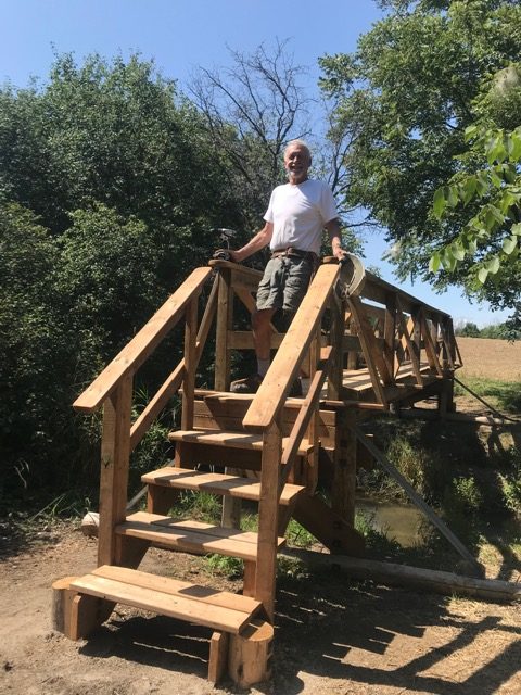
Eventually, on one very hot day in July 2020, the team assembled to build the bridge. About 8 hours of concentrated work were required. In the process, one of the team got injured by an auger and looked like he was about to go into shock, so I bundled him up and took him post-haste to Stratford Hospital Emergency Dept., where his bleeding finger was speedily attended to. I bought some turkey sandwiches from Timmes on the way back, and they proved to be a godsend to the sweating volunteers.
In September, after building the bridge, we had a dedication ceremony. The bridge was blessed with holy water being poured over it by the Catholic priest of St Agatha, who did a great job. He said bridges were usually only blessed by bishops and the like. Refreshments were provided for this occasion. Nearby landowners were invited, and the Canadian and German National Anthems were played. We were now able to overpaint all the blue blazes with white paint.
Berlett’s Road area to Musselman’s woods-Schneider’s bush
The next stage was to try to find a way to get from Berlett’s Road to Carmel-Koch again without walking on busy Notre Dame Drive. A lot of time was spent trying to crack this one, which was insurmountable because of hunting issues.
Friendly landowners east of Berlett’s Road permitted us to put a loop around the periphery of their property. It has become increasingly common to have side loops off-road to break the monotony of road travel, but these loops are not a conduit from one area to the next. This loop became known as the Drumlin Loop because of the hills called drumlins that are a feature of this property. One of these, near the road, provides an excellent lookout. Further along, next to the corner of Notre Dame Drive and Berletts’ Road, it looked like we might be able to create another side loop, but the area was largely swampy and did not prove feasible. We therefore had no choice but to go south on Notre Dame Drive to Carmel-Koch Road, at which point we turned left and east to head towards Waterloo. Part of the way along this road, we have another diversion – the Organic Farm Loop, which follows the periphery of the farm. This has proved to be a beautiful addition to the trail. Further east, still on Carmel-Koch Road, we enter the combined Musselman’s woods and Schneider’s bush section, one of the hilliest and prettiest parts of the trail, which spills out east onto Wilmot Line, the boundary between Wilmot Township and the City of Waterloo. We failed to get permission for off-road connecting pieces between Musselman’s woods-Schneider bush, and the Organic Farm loop, and from the Organic Farm loop across to Notre Dame Drive or even north through to Berlett’s Road.
The Musselman’s woods-Schneider’s bush section is extremely popular with hikers. There are so many trails that it is easy to get lost. We eventually put blazers on a chosen route from one end to the other, and traversing hikers have expressed gratitude for this. On one occasion, volunteers were approached by “hikers” who enquired about how to get to the road. They were advised to just follow the white blazes, to which they replied that they never took any notice of these and just went where they wanted. This must be the only part of the entire trail where hikers can go freely off-trail. The only significant limitation on this part of the trail is that between mid-November and mid-April, the trail is only available to cross-country skiers. Dogs are not allowed on this property. Hikers and skiers currently park on Wideman Road near the Wilmot Road entrance. During COVID, the number of cars parked on Wideman Road was at times astronomical. Plans are underway for a potential extra parking area on Carmel-Koch Road at the Musselman’s woods end. Wilmot Township has permitted this to be constructed.
Wilmot Line to Conestogo
The final major challenge to revamping the trail in Waterloo was to find a new way to the Martin Farm in Woolwich Township after leaving Musselman’s woods-Schneider bush. After we no longer had permission to walk on the farms north of Waterloo, the default route came to be along Conservation Drive after going north on Wilmot Line. At the eastern end of Conservation Drive, we headed north up Roy Schmidt Road to Stamm Woods. The problem was that Conservation Drive is narrow with no shoulder to speak of, and it is becoming increasingly busy.
Thus, we embarked on a 6-year odyssey which was ultimately successful thanks largely to Louise Finlay, the project manager for bikeways, trails and green spaces in the City of Waterloo. This visionary lady proved to be extremely helpful. A senior member of her staff walked over a proposed route to bypass Conservation Drive, then several months went by with no action because he had retired! The initial proposal was to go along Wideman Road, Laurelwood Drive, Bearinger Road, Westmount Road north, then Lake Louise Boulevard to Stamm Woods, which we would traverse to reach Benjamin Road and thus connect with the existing trail. Nearing the end of our negotiations, the late Mavis Kerr suggested going through the Columbia Forest. Half of this was owned by the City of Waterloo, and half was privately owned. The private owner allowed us to go through the woods on his property to emerge on Wilmot Line, a few hundred metres south of where we re-enter Schneider’s bush.
All this has added several km to the trail, and though a fair chunk of it is on residential streets in NW Waterloo, it has proved a great alternative to Conservation Drive. The City of Waterloo wanted to put up the signage. The final piece through Stamm Woods is on private property, and there was evidence of maple syrup harvesting here. Originally, we seasonally bypassed this, but more recently, the owner has seemed to be accepting of its use during the season. The midsection of this part of the trail parallels Bearinger Road along the Maureen Thomas Trail (alternatively known as the Beaver Creek Trail). This is the property of the Grand River Conservation Authority. They permitted us to use it, and we did not need to signpost it. The trail, particularly in the Columbia Forest, is used by many others than Avon Trail members and even by horses.
Beyond Benjamin Road and the Martin Farm, the main issue has been to keep the grass cut during the summer. We approached the Optimist Club in NW Waterloo to see if they could be responsible for this. One of their members has helped with this. There was one blip a year or two back concerning a bridge being temporarily closed beyond the Martin Farm. The trail eventually links up with the Grand River Trail in Conestogo, and this is connected to the Bruce Trail.

CONCLUSION
Though we are deeply grateful to Dr Kirkpatrick and others for their original vision and creation of the Avon Trail, its present enhanced status is hugely attributable to the many hours of excellent volunteer work often put in by senior members of our society. It seems like it is now a privilege to be on the board of the Avon Trail rather than just being part of a rescue operation.
Acknowledgements
Dennis Rawe has provided a lot of informative details, especially about the flora and fauna of the trail and the construction of infrastructure.
Edited by Brenda Tarr with photos selected by Tom Kimber
Tom Kimber – News